Current Projects
Chapter 3 - History of European Settlement
Early Explorers and Legends
Early European exploration of the Taunton River and Mount Hope Bay is shrouded in romantic legend, beginning with the Vikings. In his History of the Town of Somerset, William Hart mentions that Norwegian scholars have long believed that Leif Ericson built his “leifbooths” at Mount Hope in the year 1000 and wintered there. Thorwald, a brother of Leif, was to have spent the years 1002 and 1003 along the coast of Southeastern Massachusetts. Thorfall, another brother, sailed in 1007 and named Cape Cod “Wonder Strand,” Buzzards Bay “Stream Furth,” Martha’s Vineyard “Stream Isle” and Mt. Hope “Hop.” Map 6 shows alleged Viking routes to the new world that was included in Philips History of Fall River.
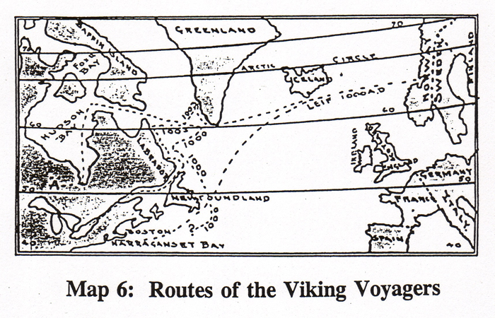
While historians are in disagreement as to where Vineland really was, there is more evidence pointing to Thorfall’s visit to Mount Hope (Hop) in the year 1007, where he left other members of his exploration party and wintered with eight men and his wife there. In Mt. Hope, Thorfall’s wife bore him a son, Snorre, who may be the first white child born in the New World. However, the Vikings were attacked by native tribes during the next fall and the party removed to Buzzards Bay until Snorre was three. After the Vikings left, it would be 500 years before Europeans would again “discover” the New World.
For a while, it was thought that the Vikings inscribed the Dighton Rock with their markings, but that legend has been discredited. However, if the Vikings made a settlement on Mount Hope Bay, it is very likely that they explored up the Taunton River.
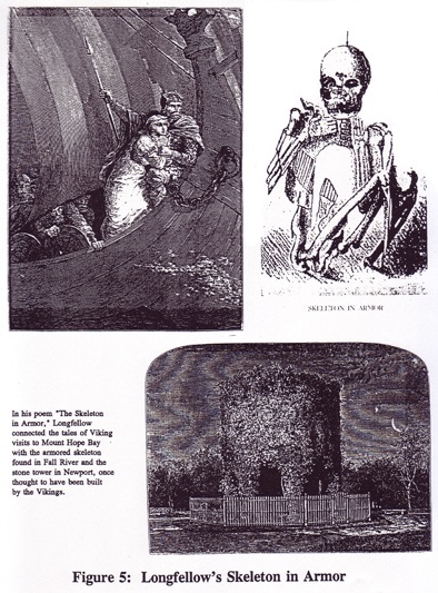
The Victorians romanticized the Vikings in their art and literature. Romantic poet Henry Wadsworth Longfellow, while visiting his brother Samuel Longfellow in Fall River (Samuel was then the minister of the Unitarian Society in Fall River), became intrigued with the Skeleton in Armour, a skeleton in perfect condition that had been excavated in 1832 from an embankment on the shores of the Quequechan River at Hartwell Street. The skeleton had a triangular brass breastplate, a belt of brass tubes and was buried in a sitting position. The skeleton gave Longfellow the idea to write “The Skeleton in Armor,” a poem that linked the skeleton in Fall River and the stone tower at Newport into a story of a rebellious Viking and his maiden. See Figure 5.
The first recorded European explorers of Narragansett Bay were John and Sebastian Cabot in 1497, although it is uncertain whether they entered Mount Hope Bay or the Taunton River.
In 1502, a Portuguese fishing captain and explorer named Miguel de Cortereal set sail from Europe to look for his brother Gaspar, who had not returned from a trip to the New World. However, Miguel, too, was never heard from again. It is believed that Miguel de Cortreal at one time entered the Taunton River at Fall River and lived among the Pocassets. The only clue that we have of his life here is an inscription on a rock in Berkley (Dighton Rock) that says in Latin “M. Cortereal 1511 V. Dei Dux Ind.” Loosely translated, this abbreviation says “by the grace of God, Leader of the Indians.” This implies that Cortereal lived among the Indians more than a century before the Pilgrims. Was he, or did he fancy himself to be, a leader of the natives? We shall never know.
Other inscriptions on Dighton Rock have led scholars in recent times to theorize that Phoenicians, Vikings, and even pirates like Captain Kidd and Blackbeard might have carved inscriptions into the rock (why this rock in particular should have been a well- used “guest book” of sorts for historical personalities is itself a mystery).
In 1524, Giovanni di Verrazano of Florence, who was exploring the New World for King Francis I of France, entered Narragansett Bay and Mount Hope Bay. He continued up the Taunton River past Fall River probably to its then navigable point in Dighton, where he noted in his report to the king that a ship could sail up its course and that thereafter it might be navigated by “small shallops.”
It was Verrazano who remarked in his journal that the landscape along Mt. Hope Bay and the Taunton River was not all wooded, as we would expect, but “park-like” in appearance, with lush grassland and occasional large trees rising a considerable distance from the shoreline. This was a result of the extensive use of firewood for fuel by native tribes for thousands of years, who kept their home fires burning continuously year-round. It was also the function of the annual burning of woodlands to encourage the growth of grassland for food for wild animals that they hunted and for ease of travel through the woodlands. Since the local tribes lived near to the shoreline, the area near to the shore would over time become denuded of trees and indeed be park-like in appearance.
By the time that Bartholomew Gosnold arrived in the area in 1602, he found that Dutch, English and French trading vessels had become frequent visitors to Mount Hope, the seat of the Wampanoags and a favorite trading point for them.
During the Colonial period, New England privateers would capture and plunder ships of nations that were at war with England, including at various times ships of French, Dutch and Spanish origin. This led to outright piracy in some instances, with Newport being reputed to be a base of privateers and a few pirates. One of the legends of the Taunton River is the Crone of the Quequechan, a mysterious person who was feared by early settlers because of her witch-like powers and who was rumored to have been the companion to Captain Kidd.
King Philips War
English settlements along the New England coast in the mid-1600’s---including those along the southern boundary of Plymouth Colony at Rehoboth, Swansea and Dartmouth - -- began to lead to friction among the native tribes and the Europeans. For years after the death of Massasoit, rumors of war between the Indians and the English became commonplace. Wamsutta---Massasoit’s eldest son, his heir and the husband of Weetamoe, squaw sachem of the Pocassets---died under mysterious circumstances following a visit to the English authorities. His younger brother, Metacom or Philip, succeeded him as sagamore of the Wampanoags. Many events, large and small, led to increased tensions between the Wampanoags and the colonists, but it was the events on Gardner’s Neck in Swansea in June, 1675 that began King Philip’s War.
On June 20, 1675, several Pokanoket warriors left their camp at present-day Warren, crossed the Kickamuit River, looted several English homes on Gardners Neck in Swansea, burned two dwellings, and forced the frightened residents to flee. Three days following the raid, a young man, John Salisbury, shot and wounded a marauding Pokanoket, who subsequently died from his wounds. The next day, Pokanoket warriors attacked and killed seven settlers on Gardner’s Neck.
Governor Winslow in Marshfield immediately sent orders to Bridgewater and Taunton to raise 200 militia to protect Swansea. However, as the poorly-prepared English militia searched in vain for Philip and his Pokanoket warriors on the peninsula that is now Bristol and Warren, Philip and his men slipped across Mount Hope Bay and landed in present-day Fall River and Tiverton.
There he enlisted the support of his ally Weetamoe, the squaw sachem of the Pocasset. After some wavering and with the pleading of her younger warriors, Weetamoe joined Philip. Her husband Peter Nunnuit (Petonowowett) joined the English, reflecting the split loyalties of the Pocassets.
The English militia removed to Taunton, where they were joined by Plymouth forces under the command of Major James Cudworth. From Taunton, the army marched along the Taunton River to “the great swamp at Pocasset,” now known as the Pocasset Cedar Swamp situated at the Fall River/Tiverton border. A portion of the Pocasset Cedar Swamp is within the watershed of and flows into the Quequechan River, which flows into the Taunton River. On July 19, 1675, the English entered the thick bramble of the swamp and engaged the forces of Philip and Weetamoe. Five English militia were killed and seven wounded, some mortally. All day, the English advanced and the Wampanoags fought a spirited rear-guard action. When night fell, the English retreated from the swamp and the Wampanoags disappeared.
The next day, from his garrison on Mount Hope, Cudworth wrote to Governor Winslow:
“On Monday [July 19th] following we went to see if we could discover Philip, the Bay forces being now with us; and in our march two miles before we came to the place of rendezvous, the captain of the Forlorn was shot down dead; three more were killed or died that night, and five or six more dangerously wounded. The place we found was a hideous dismal swamp [Pocasset Cedar Swamp]; the house or shelter, they had to lodge in, contained, in space, the quantity of four acres of ground, standing thick together; but all women and children fled, only one old man, that we took there, who said that, Wittoma [Weetamoe] was there that day, and that Philip had been there the day before, and that Philip’s place of residence was about half a mile off; which we could made no discovery of, because the day was spent, and we having dead men and wounded men to draw off.”
For a second time, the colonists had let Philip escape. The Pocasset Swamp fight was a pivotal one for the course of the war, because it meant that, with Weetamoe’s warriers, the combined Pokanoket and Pocasset tribes, under Philip’s leadership, would expand the war north into all of New England. Any chance of a quick capture of Philip was ended.
From the Pocasset Swamp, Philip and Weetamoe swept east of the “Watuppa Lake” and north along the Mawry Path until they reached the Taunton River at a Pocasset ferry landing immediately north of Mother’s Brook (later known as Winslow’s Point). There they crossed and proceeded north into Central Massachusetts to join with their Nipmuc allies. The Pocassets warriors who joined Philip were said to number about 300.
Map 7 shows the probable route of escape of Philip and Weetamoe.
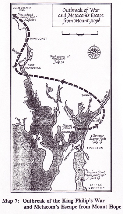
The battle of the Pocasset Swamp was a fateful one for the English and the natives, for the escape from Winslow’s Point resulted in the igniting of King Philip’s War. Had the English intercepted and captured Philip and Weetamoe before their crossing of the Taunton River, the history of New England would have been dramatically changed.
The war caused considerable loss of life and widespread destruction of the Colonial settlements. All of the settlements west of Concord were evacuated.
On February 10, 1676, Philip and his allies set upon Lancaster and destroyed the town. One of the hostages taken was Mrs. Mary Rowlandson. Mrs. Rowlandson later wrote an account of her captivity and forced march with Philip’s war party. In one of her accounts, she describes Weetamoe as a proud squaw sachem who took particular care of her appearance:
“A severe and proud dame she was, bestowing every day in dressing herself neat as much time as any of the gentry of the land, powdering her hair and painting her face, going with necklaces, with jewels in her ears, and bracelets upon her hands. When she had dressed herself, her work was to make girdles of wampum and beads.”
After a year of successes, Philip’s fortunes began reversing. The Colonists and their Indian allies, such as the Mohawks, began to gain ground.
In August of 1676, Weetamoe, accompanied by 26 warriers, took refuge in a dense swamp near Taunton. It appears that she was trying to reach Narragansett territory. However, they were surprised by militia from Taunton, who captured the Pocassets. Under the protection of her warriors, Weetamoe escaped and attempted to cross the Taunton River on a makeshift raft. She never made the crossing and drowned in the river. She was found dead the next morning on the Somerset shore.
In King Philip’s War, Eric B. Schultz and Michael J. Tougias relate the sad end to the proud life of Weetamoe, the squaw sachem:
“Weetamoe’s corpse was mutilated and her decapitated head sent to Taunton, where it was placed on a pole, paraded through the streets of Taunton, and left on public display at the Taunton Green. Increase Mather describes the scene: ‘The Indians who were prisoners there knew it presently, and made a most horrid and diabolical lamentation, crying out that it was their Queen’s head.’”
The death of Weetamoe signaled the end of the Pocassets who followed her and Metacomet, for those who were not killed were sold into slavery to the West Indies sugar plantations. Those Pocassets who sided with the English were settled in the area now known as the Maplewood section of Fall River along Stafford Road.
However, the lingering bitterness from the atrocities committed by both sides during King Philip’s War caused constant friction between the Indians and the Colonists. As a consequence, the Indians asked to be moved to a more distant location. Benjamin Church facilitated their relocation to the eastern side of North Watuppa Pond on land that he owned, what later became known as the Watuppa Reservation and which is today part of the watershed of the City’s water supply.
Philip was hunted down and killed in a wooded swamp in Pocanoket territory on August 12, 1676 by a Pocasset warrior who had remained loyal to the English. Benjamin Church of Little Compton, pursued Philip and found him in what is now Bristol. Church was later to become active in the commercial affairs of the village that was to become Fall River.
Philip’s body was drawn and quartered. His head was decapitated and his skull placed on public display on a pole in Plymouth for a whole generation, for 20 years. His wife and nine-year-old son were sold into slavery.
Never again in Southern New England would the Indians and the settlers live side by side, as they had before King Philip’s War.
Freetown in the Colonial Era
The first settlers to the area that became Freetown arrived around 1680. There appears to be two sources of immigration: one from Plymouth and one from immigration arriving via Newport.
Immigration to New England was founded on religious impulses, in order to establish model Christian communities that would allow the emergence of a new individual, untainted by the corruption of European society. Therefore, before the General Court would approve a new settlement, the environment of the area to be settled must sustain approximately 30 to 40 families, or enough to support a minister. The Puritan magistrates were determined that none of its model communities be without the religious oversight of a spiritual leader.
There were two environmental requirements for new settlements: (1) they should contain adequate salt marsh and (2) suitable upland grazing land. The upland would provide cropland and pasture land for livestock while the marshes would provide the salt hay for winter fodder. Unlike the plantation economies of the southern American colonies and the West Indies, the Puritans (and Pilgrims) decided that the most appropriate economic base for their New England would be fisheries and the growing of livestock. Locations along the coast that had extensive salt marshes, such as Rehoboth, Swansea and Dartmouth were especially attractive and developed early communities in the 1660’s. Later, the salt marshes of Assonet Bay and its upland fields became recognized as a prime site for a new community.
Coastal locations were also the easiest to access. Before the emergence of the railroads in the 1840’s, most population centers in the Colonial era grew along navigable waterways, since water vessels provided the fastest, easiest and least costly way of moving goods between cities and regions. Roadways were too rudimentary to allow the carrying of major amounts of freight long distances.
As with most New England towns, the main economy of Freetown was subsistence agriculture. Virtually all of a family’s needs were met through its own resourcefulness. Farm families grew their own food; raised their own livestock for meat, milk, butter and cheese and eggs; made their own clothing on foot-powered spinning wheels and looms from wool provided by their own sheep; grew apples for their hard cider; made their homes, barns and tools from lumber provided by their own wood lots; obtained fuel from those same wood lots; and generally provided for themselves.
A Scotsman, Chancellor Livingston, observed in 1813 that the Yankee farmer “can mend his plough, erect his walls, thrash his corn, handle his axe, his hoe, his sithe, his saw, break a colt, or drive a team, with equal address; being habituated from early life to rely on himself he acquires a skill in every branch of his profession, which is unknown in countries where labor is more divided.”
Cottage industries such as making shoes, hats or other items---and surplus agricultural products---provided cash for those items that could not be provided by themselves, such as iron parts of tools, grinding of corn and grains, sawing of lumber and finishing of their home-made cloth (which was brought to a fulling mill for processing) salt, sugar and rum.
The early industries in the three villages in Freetown on the Taunton River (Assonet, Steep Brook and Falls River) were all related to agriculture and were the same as in all other New England communities: a saw mill made lumber from locally-cut logs, a grist mill ground the farmer’s grains and corn; a fulling mill processed hand woven cloth into a finer, more durable and workable fabric; and a blacksmith shop was the iron works that provided the iron parts for tools, plows, harnesses and household implements, in addition to horseshoes.
These early industries required water power to move the water wheels that powered the saws and grinding wheels of these early mills. The Taunton River was itself too large and with too little gradient to harness for water power and, even if it could, the resulting flooding would cause the loss of thousands of acres of land. However, the tributaries of the Taunton River were ideal for this purpose. They had sufficient gradient or “fall,” were small enough to be harnessed with small dams, and the amount of water flowing through the streams was manageable for these early mills. The tributaries of the Taunton River in Freetown that became important for mills were the Assonet River, Steep Brook and the Quequechan River. Barnabas Clark operated a saw mill, grist mill and fulling mill on Steep Brook.
Shipbuilding began early on the Taunton River, probably about 1680. At first, small vessels were built to serve local needs, such as fishing. Later, larger vessels were built to transport firewood, building lumber and farm produce to the emerging towns of Providence, Bristol and Newport. In the 1700’s, this shipbuilding activity on the Taunton River grew to serve the coastal trade, serving cities such as New York, Philadelphia, Baltimore and Savannah.
The specialized plantation economies of the West Indian sugar islands and the southern American colonies (cotton and rice) could not supply themselves with sufficient food and other basic items. Resourceful New Englanders saw a nearby market and responded. As a result, New England became the breadbasket of the plantation economies. Its farmers provided these monocultures with essentials such as flour, biscuits, salted beef, salted pork, salted fish, butter, cheese, peas, rooted vegetables, lumber and barrel staves, as well as horses and other livestock.
In 1689, in Brief Relation of New England, a contemporary remarks that:
“The other American plantations cannot well subsist without New England, which is by a thousand leagues nearer to them than either England or Ireland; so that they are supplied with provisions, beef, pork, meal, fish, &c, also with the lumber trade, deal boards, pipe [barrel] staves, &c, chiefly from New England. Also the Caribee Islands have their horses from thence. It is then, in a great part, by means of New England, that the other plantations are made prosperous and beneficial.”
In 1660, Governor Winthrop mentions that the Massachusetts Bay Colony had prospered to such an extent that it was now able to export farm products and build a shipping industry, to the extent that “the country doth send out great store of biscott, flower, peas, beife, porke, butter, & other provisions to the supply of Barbados, Newfoundland, & other places, besides the furnishing out many vessels & fishing boats of their owne, so as those who come over may supply themselves at very reasonable rates.” Resourceful New Englanders supplied provisions not only to the West Indian Islands and southern colonies but also north to the fishing villages of Newfoundland.
The trading between New England and the West Indies and the southern colonies in farm products and fish (the famous salt cod) required large numbers of marine vessels of all kinds, sparking the growth of the New England shipbuilding enterprises in the 1600’s, including shipyards all along the length of the main stem of the Taunton River, from Bridgewater to Mount Hope Bay, but particularly in Somerset, Dighton, Assonet and Steep Brook. This shipbuilding activity expanded into larger vessels as trade with Europe, Africa and the West Indies increased. By the 1700’s Somerset, Assonet and Dighton had become major shipbuilding centers on the Taunton River, with minor shipbuilding occurring at Steep Brook and Fall River.
The coastal shipping trade required that ships proceed inland up a river to its most navigable point, in order to reach markets as far inland as possible. During the Colonial period, the farthest navigable point on the Taunton River was in Dighton, a few miles above where the Assonet River enters the Taunton. With its inland location and its protected harbor, Assonet therefore became the transfer point for goods brought by oxen team from inland sites such as Taunton, Middleborough, Berkley and even Fall River. Goods such as farm produce, manufactured products and wood were loaded at Assonet for shipment to points south, including Providence, Bristol, Newport, New York, Philadelphia, Baltimore, Charleston, Savannah, the West Indies and foreign ports.
In return, ships brought back salt, molasses, sugar, tobacco, rum, tropical fruits, rice and coffee from the West Indies, the southern American colonies and even South America.
Vessels from the Taunton River seemed to have a particular affinity for the southern colonies, particularly in Georgia, where they spent the winter and then returned in the spring to be outfitted in Assonet and Somerset. A commentator in 1897 remarked that “to Georgia were shipped beef, pork, livestock, dairy products, apples, hay, and in fact much the same products that went to the West Indies. The rice, indigo and cotton plantations of the southern coastal plains were comparable in many respects to the sugar plantations. They found specialization in their ‘cash’ crops so profitable that it seemed as if they could not afford to raise their own food supplies.”
Coastal trading vessels built in Assonet and Somerset typically had drafts of only four feet, in order to navigate the shallow waters of the southern inland waterways where the plantations were located.
In his History of Somerset, William A. Hart states that the majority of the New England shipping fleet would winter in the south and that “Darien, Georgia was the favorite wintering spot for vessels from Mt. Hope waters since they could always find there the familiar craft and faces of their home neighborhood. For many years, it was said that if during the winter you wanted news of Assonet, Freetown, Dighton or Somerset you would do best to write to Georgia for it.”
By 1760, the ports of Dighton, Somerset and Assonet equaled Plymouth in the number of vessels and goods transported. Maps 8 and 9 show the importance of the Taunton River corridor in the region during the Colonial and Federal periods.
.jpg)
Steep Brook in the Colonial Era
Steep Brook was one of the villages in Freetown that had a history similar to Assonet (and which harbored an active rivalry with Assonet). Steep Brook was also a location for shipbuilding, but lacked Assonet’s protected harbor.
Because of its location, Steep Brook became the hub of travel on land and on the Taunton River. As early as 1808, stage coaches began regular service between Boston and Newport, first on alternating days then on a daily basis. The stage coaches stopped at the Green Dragon Inn located at the corner of North Main Street and Wilson Road to change horses, to check equipment at the blacksmith shop, and for passengers to rest and dine. The sign on the inn said “Beer, Oysters and Horsekeeping.” From Newport, connections could be made with New York on fast sailing packets. Sailing from Newport saved two or three days on the Boston to New York route over the shore stage line, depending on the season and road conditions.
Previous to 1808, the Boston to Newport ferry operated via Attleborough, East Providence and Bristol Ferry, where a somewhat undependable ferry brought passengers over to another waiting stage coach on Aquidneck Island. However, with the building of a bridge at Tiverton Narrows to the island, the route changed and came through Taunton and Fall River.
The stage left Worthington’s Tavern on Bromfield Street in Boston every day except Sundays at 5:00 AM and arrived at Newport at 6:00 PM, if not delayed. The stages carried six passengers and were often followed by a baggage wagon.
In its dependability and comfort, the stage line to Newport and the fast packet to New York were the predecessors of the “Boat Train” and the Fall River Line to New York.
At the bottom of Wilson Road on the Taunton River, Chace’s Ferry carried passengers across the Taunton River from Dighton and Somerset who needed to make connections with the stage for either the Boston or Newport destinations.
In addition, Steep Brook was a connection for stage coaches running from New Bedford and Providence. A bridge crossing at the Narrows was not made until 1828, so the only practical way for freight and passenger travel in an east/west direction from New Bedford to Fall River and Providence was via Wilson Road at Steep Brook. In 1825, regular stage coach service began between New Bedford and Providence, with passengers crossing at Slade’s Ferry (site of the current Brightman Street Bridge).
At first, passengers crossed the Taunton River by changing stage coaches, since early sailing ferry craft were not stable enough to safely carry carriages and horses. Providence coaches unloaded passengers on the Somerset side and New Bedford coaches unloaded on the Fall River side, with the coaches returning to their respective destinations.
In order to have continuous stage coach travel between New Bedford and Providence, sail boat ferries were replaced in the next year, 1826, with larger horse-powered ferries that allowed horses and coaches to cross the Taunton River at Slades Ferry.
Steep Brook was the site of much shipbuilding activity. At the (Miller’s Cove) where the Fall River Country Club is now located, there existed from the early 1700’s Thurston’s Wharf, where vessels were made for the West Indies trade. At this location, there was also a coopers shop, where barrels were made to transport goods to and from the West Indies and southern colonies. There was also a tavern located at this location until 1776, when it was destroyed by fire.
Next to Thurston’s Wharf was Miller’s Wharf, on the cove that bears his name. Robert Miller was a shipwright and built a shipyard here after purchasing the lot in 1738. Robert’s son and grandson enlarged the shipyard in subsequent years. Arthur Phillips, in his “History of Fall River,” states that many vessels were built here, including the “George Washington,” built in 1838. That vessel made trips down the Taunton River to Charleston, Savannah, and Cuba to trade in cotton and rice. In 1849, in the gold rush of ’49, Captain Miller sent the George Washington around Cape Horn to the California gold fields with a crew from Steep Brook. Map 10 shows Steep Brook in 1871.
.jpg)
Fall River in the Colonial Era
During the Colonial era, the location of the “West End” of Freetown above and below the Quequechan falls on the Taunton River did not lend itself to development. The village lacked an adequate protected harbor and was subject to westerly and southwesterly winds from Mount Hope Bay. The steep slopes rising out of the Taunton River---a unique situation along the otherwise flat landscape of the river---put this location at a disadvantage because it meant that to access the interior required “double teaming” of oxen up the steep hill. It was also not as inland as the villages of Steep Brook and especially Assonet, which was in close proximity to large areas of fertile agricultural land. The wilderness above the Quequechan falls had poor till soils and was mostly suitable for grazing sheep.
Colonial Industries on the Quequechan River: However, the Quequechan River provided the power for the usual Colonial industries of saw mill, grist mill and fulling mill. Thomas Borden owned a saw and grist mill on the south side of the river where it entered the Taunton River. Thomas’ brother, Joseph Borden, operated a fulling mill at one of the falls near the top of the Quequechan. Steven Borden owned the north side of the Quequechan River and operated a saw mill and a grist mill there. The profits developed by the Bordens, Durfees and Bowens from these early enterprises grew over time into a sizable amount of the capital that later became invested in textile manufacturing. The technical and entrepreneurial skills learned by these capitalists in these early businesses became important when the Industrial Revolution came to the city.
In his Centennial History of Fall River, Massachusetts, Henry H. Earl describes the early industry of the young Richard Borden, who at 17 years of age ran a grist mill on the Quequechan River and, with his brother Jefferson Borden, “would go down to Prudence and Conanicut [Jamestown] Islands, in the sloop Irene and Betsy, which carried about 250 bushels of corn, and having secured a load, to return to Fall River and tie up at a little wharf within the creek, and discharge directly into the mill. The Irene and Betsy was also a sort of packet between Fall River and the neighboring places, and the surplus meal was sold in Warren, Bristol or Providence, and a return freight secured, of provisions, groceries, cotton, etc.”
As business improved, another grist mill was built at the next-highest falls on the Quequechan. In order to facilitate the movement of corn from the sloop on the Taunton River to the mill on the Quequechan, a tram was built with a car running up and down the hill pulled by a rope and operated by the same water wheel that powered the grist mill.
A small cove existed at the base of the Quequechan River as it entered the Taunton River that provided some protection for small vessels, but the cove could be entered only at high tide over a shallow entranceway. See Map 11 for the West End in 1800.
.jpg)
The Salt Works: Salt has always been an important element in animal life. However, it was an especially important commodity before the advent of modern refrigeration. Salt was used universally for the preservation of fish and meat. The salt cod became the mainstay of the Massachusetts economy.
The highest quality salt came from the West Indies, and one of the most important commodities in the extensive trade that emerged between New England’s coastal towns and Barbados and other islands in the Carribean was salt. This trade continued until the advent of the Revolutionary War, when the British Navy cut off trade between the American Colonies and the West India islands. The Freetown Town Meeting voted to send ships out to obtain salt from the islands in defiance of the blockade, but it is not known if the authorization was carried out.
As a result of this blockade, the Continental Congress directed coastal towns to begin making their own salt from sea water. This salt was inferior to the salt from the islands, but it was better than no salt at all. Sea water averages 3-4 parts of salt per 100 parts of water. “Salt works” soon began being established in towns all along the Atlantic coast.
In July, 1777, the Town of Freetown voted to establish a salt works at the southernmost point of the town, where the Taunton River water would be most brackish. Such a salt works was established at what is now the northwesterly corner of Davol and Brownell Streets, where the Mechanic Mill now stands. At that time, the river shoreline was probably closer to this location.
Heating the water to evaporate the liquid was considered too expensive, and a method of natural evaporation using a windmill was developed. Arthur Phillips, in his History of Fall River describes that at the Davol/Brownell Streets location, a large frame was erected measuring 70-100 feet long and about 30 feet high:
“This frame was loosely stacked with fagots [large sticks] from top to bottom. The sea water was then pumped by windmills to the top of the frame and allowed to trickle slowly down over the fagots. Thus a greater surface for evaporation was obtained. The more concentrated salt solution was caught in shallow catch basins beneath the frame and then recirculated over the fagots until the salt began to crystallize out. The salt was knocked off of the fagots, and the brine was then run off into wide, shallow settling basins where the rays of the sun removed the rest of the water. The crystallized salt was worked over with rakes to secure as complete drying as possible. Sometimes a purification process was attempted but it is doubtful if this was done very often The settling basins were provided with wood covers for protection in case of rainy weather. Of course, the warmer the climate the shorter was the time required to produce a yield of salt.”
In Dartmouth, the next town to the east, a salt works was erected in Padanaram, at the western side of the bridge that leads into that village.
The 1800 map of Fall River shows a “salt house” near where the Quequechan enters the Taunton River. In 1780, the town sold the salt works for one year at public auction, the rent being ten bushels of salt, payable “in the fall.”
The Wood Slide: The 1800 map of Fall River shows a “wood slide” on the hillside north of the falls and Central Street. In his History of Fall River, Phillips says that “there was then a wood slide through which cord wood was slid to a wharf from which it was loaded into small vessels and shipped for sale in Newport and Bristol where the local supply of wood was very limited.”
The landscape along the coast in this area was virtually denuded of forest because of the thousands of years of use of the forest for heating purposes by the native tribes. Each family kept a fire burning year-round, as did the Colonists later. Within their immediate vicinity, coastal towns found a short supply of cord wood for heating, for lumber for building dwellings and other structures, for barrel staves and for many other uses.
While the coastal areas were mostly grassland and cultivated fields, there was extensive woodland in the interior areas above the Quequechan River falls and especially beyond “Watuppa Lake” (before the Narrows was connected with a causeway in the early 1800’s, North and South Watuppa Ponds were one lake). Sailboats would load the cut wood on the boats along the shore of the ponds and travel down the Quequechan River and unload the wood where the Quequechan River ceased to be navigable above Main Street. From there, the wood was loaded on to teams pulled by oxen and brought to the edge of the hill near what is now Central Street.
Because of the steepness of the hill and because roads were unpaved well into the 1800’s, it would have been dangerous to bring the oxen teams down the hill on muddy paths strewn with ledge outcroppings. It was much safer to bring the wood to the top of the hill and slide it down to the base of the slope to a wharf where waiting boats would take it away to Newport and Bristol.
It is likely that this slide existed for about 150 years, from about 1680 until after 1830, when schooners began bringing Pennsylvania coal to Fall River up Mount Hope Bay and the Taunton River.
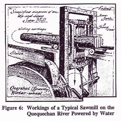
The preparation of logs into sawn lumber went through various technological evolutions. Initially, logs were sawn in “saw pits.” These pits were holes dug into the ground with logs placed over them. The two-man saw was worked by a man in the pit and one above. There was very likely many such pits along the Taunton River during the early years of settlement, but their locations have not been recorded.
With the development of the up-and-down saw mill, using multiple gang saws, the local tributary streams of the Taunton River could be harnessed for powering saw mills. Figure 6 shows the workings of such a mill. Circular saws were invented later.
Fall River and the American Revolution
During the Revolutionary War, the British systematically burned coastal towns that sided with the Revolution as a means of demoralizing and weakening the resistance of the rebels. Local merchant ships were especially decimated. The British held Newport and therefore secured the inland coastal areas on Narraganset Bay, Mount Hope Bay and the Taunton River. However, certain anti-British towns such as Fall River and Tiverton were making gunpowder, manufacturing small arms and forming militia companies of Minutemen, and these rebellious towns therefore represented potential support for Continental troops against a possible land operation against Newport.
Colonel Joseph Durfee, who later started the first cotton mill in Fall River, was appointed captain of a company of Minutemen. They conducted such operations as guarding the shores of Mount Hope Bay and the Taunton River and prevented British ships captained by Wallace, Asque and Howe from landing their troops. Fall River’s Minutemen under Colonel Durfee also marched to cover the retreat of American troops from New York and later joined with other troops and took an active part in the Battle of White Plains. After the British took possession of Newport, the Fall River Minutemen covered the retreat of Colonel John Cook and his troops from Aquidneck Island at the Bristol ferry (now the site of the Mount Hope Bridge). This operation was hazardous because of the small boats used as ferries at the time and because of the many British spies on the island.
At Fall River, Col. Durfee commandeered a store at the end of the wharf, at a site that later became the Fall River Iron Works, for use as a guardhouse. Sentinels were stationed there every evening, with orders to shoot if an approaching boat did not respond after being hailed three times. Colonel Durfee later related his recollections of the battle of Fall River, as quoted by Phillips in his history:
“ Not long afterward, Samuel Reed, acting as guard, discovered boats cautiously approaching the shore and receiving no answer fired upon them; that the whole neighborhood was soon in arms; that from behind a stone wall the guard kept up a rousing fire upon the enemy until they brought their cannon to bear upon us and fired grape shot among us, whereupon a retreat was ordered.”
“Two of the guard were sent to remove the planks which has been laid over the lower stream for people to cross upon, and that we retreated slowly until we reached the main road where the bridge now crosses the stream [North Main Street where it crosses the Quequechan River] and there we formed and gave battle, whereupon the enemy retreated leaving one dead and another bleeding; that they carried away their wounded; that before the soldier who was left behind expired he said that there were 150 British in the charge commanded by Major Ayers; that upon landing the enemy set fire to the new house of Thomas Borden, then to a grist mill and saw mill belonging to Mr. Borden, both of which stood at the mouth of the fall river [Quequechan River]; that he saw them set these buildings on fire.”
“That in their retreat they set fire to the house and other buildings belonging to Richard Borden, who was then an aged man and took him prisoner, but they were pursued so closely that the building which they had set fire were saved; that we continued to fire upon them as they passed down the bay; that they ordered Mr. Borden to stand up in the boat so that we would desist firing upon them but he refused to do this, and threw himself upon the bottom of the boat; that while lying there a shot killed a British soldier standing by his side; that Mr. Borden refused to answer questions and in a few days was dismissed on parole; that this engagement was on Sunday, May 25th, 1778; that they buried the two [British] soldiers near the south end of the Massasoit factory.”
During the later part of 1778, the militia procured supplies and built flat-bottomed boats and scows to prepare for crossing into Aquidneck Island with the intention of dislodging the British from Newport. The militia were joined by troops led by Lafayette, Greene and Sullivan and marched down the island towards Newport, where they were to be joined by the French fleet. Lafayette stayed at the home of Col. Durfee that still stands at the bottom of Cherry Street.
<Back