
| Get Involved |
Mission Statement |
Calendar of Events |
Just For Fun |
|||
| Associates | Projects | Spotlight |
Fall River Open Space Plan
i.) Surface Waters
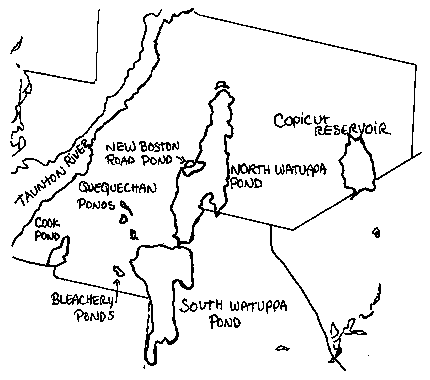
Ponds
| Fall River Pond | Area | Shoreline | Depth |
| Bleachery Pond (west) | 2.1 acres | 1,750 feet | |
| Bleachery Pond (east) | 6 acres | 2,050 feet | |
| Cook Pond | 154 acres | 2.6 miles | 18 feet (max) |
| Copicut Reservoir | 800 acres | 4.2 miles | 37 feet (max) |
| New Boston Road Pond | 18 acres | 3,505 feet | 3 feet |
| North Quequechan Pond | 12 acres | 4,456 feet | |
| South Quequechan Pond | 14 acres | 3,689 feet | |
| Middle Quequechan Pond | 16 acres | 3,824 feet | |
| North Watuppa Pond | 1760 acres | 12.4 miles | 25 feet (max) |
| South Watuppa Pond | 1446 acres | 10.4 miles | 15 ft(avg), 22 ft(max) |
| Sawdy Pond | 363 acres | 4 ft(avg), 7 ft(max) |
South Watuppa Pond
This 1446 acre warmwater pond has an average depth of 15 feet and a maximum depth of 22 feet. Transparency is low at three feet and aquatic vegetation scant. The bottom is composed of rubble, rock and muck and there are numerous rubble-strewn shoals. Parts of the ten-mile shoreline remain wooded but only a small portion is accessible to the public.
Access to the pond is provided through a paved boat ramp and parking area at Dave's Beach located off Route 24 at the northeast corner of the pond just south of Route 195. Parking space is available for approximately 50 vehicles.
Cook Pond
This 154 acre warmwater pond has an average depth of 10 feet and a maximum depth of 18 feet. Transparency in the pond is 6.5 feet and the bottom is composed of rubble, rock, and muck. Emergent wetland vegetation is common along the 2.6 miles of shoreline and submerged vegetation virtually nonexistant.
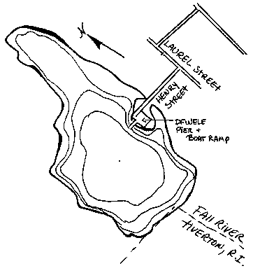
Access to the pond is provided by a Division of Fisheries, Wildlife, and Environmental Law Enforcement (DFWELE) fishing pier and paved boat ramp at the end of Henry Street, which is off Laurel Street. The paved parking area can accommodate 50 vehicles.
In 1993 the state Public Access Board (the construction arm of DWELE) rebuilt the ramp, parking lot, and the handicapped-accessible fishing pier. Day to day maintenance is controlled by the Fall River Department of Public Works. Today, the parking lot is in poor condition (i.e.potholes) and requires improvement.
Northern Gama Grass (Tripsacum dactyloides), a rare species of grass, inhabited the eastern shores of Cook Pond until sometime within the last decade when, it is believed, residential development wiped out the last patches of habitat.
Historical Alteration of Water Resources
When the European settlers first arrived, the land mass which later became Fall River was a wilderness area extending from several miles east of the Watuppa Ponds west to the Taunton River and Mount Hope Bay. Water flowed from the freshwater ponds into the river and estuary via a stream about two miles long.
The stream flowed out of South Watuppa for about one and a half miles in a narrow and fairly straight channel until it reached the area which is now Main Street. Then it cascaded over an escarpment, through a deep gulf with high rocky sides and fell about 129 feet over a series of ledges into a pond at the base, which emptied into the Taunton River. The native American name for the stream, "Quequechan" was apparently inspired by the beauty of the falls. The name denoted "falls river", "leaping waters", or "flying fish".
According to the Phillips History of Fall River, Fascicle III, the present location of Government Center looked something like this:
"...There the waters of the river...collected in a pool...From this point the waters dashed over the hillside, from a height of one hundred and fifty feet to the lower basin...Among the lily pads, in this upper pool was a resting place where game birds found a hiding place in the reeds and bushes along the banks, and in the spring, the fish could be seen leaping up the falls."
The abundant freshwater fish stocks included yellow and white perch, pickerel and horned pout. In the Taunton River, yearly runs of shad and herring provided overwintering foodstocks for the early settlers. Sturgeon and eels were also common and tautog, scup, striped bass and tomcods were plentiful in the Mount Hope Bay. Black bears, wolves, white-tailed deer, hares, wild turkeys, ruffled grouse and other game birds inhabited the forests.
According to maps and historical accounts, an intricate network of small streams and ponds crisscrossed the land north and south of the Quequechan, all of which have suffered diversion or alteration in the intervening two hundred years.
Two major land purchases in the 1600's resulted in the acquisition of a large portion of the present city by private parties, Europeans who had settled in Plymouth County. The Freeman's Purchase in 1657 from the Wampanoag Chief Wamsutta involved land north of the Quequechan River. The deeds included "all the waters, brooks and ponds" within the purchase boundaries and thus left the ownership of the river and the Watuppa Ponds in the hands of Benjamin Church. Church later sold these lands and water rights to Richard Borden in 1714. Most of the land south of the Quequechan (including Cook Pond) was acquired by Stephen Borden through the Pocasset Purchase in 1680.
During the 1700's the Quequechan River turned the water wheels of saw mills, grist mills and fulling mills which were built along the banks. When the era of the cotton mill dawned, the potential water power provided by the last quarter-mile of the river as it tumbled over the escarpment attracted mill developers in the early 1800's. While Fall River's first cotton mill was built in 1811 in a stream emanating from Cook Pond, the second, Troy Manufactory, was constructed at the base of the Quequechan Falls in 1813. At that time, the mill owner constructed the first dam on the river to reserve water. This event signaled a period in the city's history during which our surface waters were chiefly regarded as commodities to be used to drive industrial and econnomic development without evaluation of potential environmental consequences. Other mills located along the Quequechan Falls and, in 1827, a second dam was constructed by the Watuppa Reservoir Company, an association of mill owners.
This company subsequently bought or otherwise acquired flowage rights along the Quequechan River, as well as along both Watuppa ponds. These actions secured for the Reservoir Company absolute authority to withdraw unlimited amounts of water and to dam or otherwise manipulate the flow of the Quequechan to accomodate the operation of the mills.
Fall River's town hall was first located in the northern (Steep Brook) section of the city. In 1845 a new town hall was constructed in a more central location on Main Street, and this portion of the river was buried in an underground pipe.
During the 1800's and early 1900's legal restrictions on filling or alteration of wetlands and waterways and on discharges of wastewater into waterways were minimal to non-existant. Historical maps suggest that large amounts of wetlands filling occurred as the riverside land was developed. Industrial intake pipes along the length of the river withdrew water for use in the mills and outflow pipes discharged industrial wastewater and sewerage. In addition, the city's system of combined sewers and storm drains resulted in decades of discharges of raw sewerage to the river when the flows exceeded the capacity of the conveyance system and overflowed during significant rainstorms at six discharge points along the Quequechan. Historical accounts contain numerous references to stagnated flow and extremely degraded water quality, but the fact that there was apparently no public outcry about the condition of the river suggests a widespread acceptance of the practice of using natural streams and rivers as waste canals.
What is widely regarded as a death blow to the Quequechan River was struck in the 1960's, when the Federal Highway Administration constructed Interstate 195 through what remained of the open channel. The last remnants of the original falls were all but obliterated, and the upstream portion of the river (east of Plymouth Avenue) was moved to make way for the highway.
The Taunton River and Mount Hope Bay form the western boundary of Fall River. This portion of the river is broad, flat and subject to tidal flow, with brackish water reaching beyond the city line on the north. The Fall River shoreline underwent significant alteration in the nineteenth and early twentieth century as tideland area was filled in to accommodate shipping, docking and loading facilities. This alteration resulted in the elimination of many areas of saltmarsh, eelgrass and beaches. Today only a few small areas remain.
Pollution discharge also affected these waters; prior to about 1948 combined sewerage and stormwater lines emptied directly into the river without the benefit of treatment and shellfish beds in this area were closed around 1948 by the U.S. Public Health Service as a result of concerns about contamination. Between 1948 and 1952 a treatment plant was built at the present Bay Street site and an interceptor sewer line conveyed the combined flows to the treatment plant, with the CSO discharge points provided for wet weather overflows.
Many smaller streams fared little better or even worse than the Quequechan River. The Bleachery Ponds near the South Watuppa were created for mill use by impoundment of small streams, and Sucker Brook itself has been rechanneled to accommodate road building and other construction. An open stream originally flowed out of Cook Pond (or Laurel Lake as it was formerly called) to Mount Hope Bay. It now flows in an underground pipe.
In the early 1900's the Watuppa Reservoir Commission became concerned about the pollution levels in three brooks which fed the North Watuppa Pond from the east side - Highland, Terry and Cress Brooks. The Commission received authorization from the state to construct the Interceptor Drain along North Watuppa's western shoreline around 1915. This artificial channel diverts streams and surface runoff from a large land area on the west side of the pond to the South Watuppa, thus protecting water quality in the North pond, but eliminating a significant portion of the watershed. New Boston Road Pond and Duck Pond which lie between Route 24 and North Watuppa Pond were created out of a natural cove when a private landowner built a causeway and road across it to improve access to the Interlachen property.
The present site of the Fall River Industrial Park originally encompassed the headwaters of three brooks. Of these, Mother's Brook still flows northwest to the Taunton River, but many of the wetlands that fed this stream have been filled or altered. Steep Brook formerly flowed southwest out of an area near the present Currant and Graham Roads and another stream flowed from this area east to the North Watuppa. When the Park's roads were constructed, the natural stream courses were diverted into a system of drainage swales which run along the roadsides. Water flowing to the east is diverted into a storm drain before it crosses Riggenbach Road to prevent it from proceeding towards the drinking water supply, and an additional land area was thus removed from the North Watuppa watershed. Water flowing west is directed to a large detention pond in the corner of the park. The present day "Steep Brook" now emanates from this Pond.
Phillips History provides a partial inventory of some smaller streams, ponds or other aquatic sites of Fall River, all of which have been altered from their natural state:
Tampered With:
| Bush Pond | Between Oak Grove and Eastern Avenues, fed by the former Cress Brook. Appears to be undergoing eutrophication, probably from decreased inflows. |
| Bliffins Beach | Shoreline bathing spot on Taunton River near the outlet of Steep Brook. |
| Crab Pond | Once an inlet of the bay, now an impoundment connected to the remains of the Quequechan River by an artificial channel. |
| Cress Brook | Once flowed from Stanley/Robeson Street area across Garden Street and New Boston Road to North Watuppa. All but obliterated. |
| Highland Brook | Originally flowed from area of St. Patrick's Cemetery to North Watuppa. Remaining stream has been partially rechanneled and now empties into the Interceptor Drain which conveys it to South Watuppa. |
| Mothers Brook | Flows northwest through BFI landfill property then continues to Taunton River. Past filling of adjacent wetlands has resulted in sedimentation problems; in past years, high coliform counts have been measured. |
| Steep Brook | North branch formerly originated in present Industrial Park area. Reduced stream flows into the Taunton River. |
| Sucker Brook | Flows from Stafford Pond to South Watuppa. Portions of bordering wetlands have been filled and stream has been partially rechanneled, resulting in major phragmites invasion. |
Gone But Not Forgotten:
| Aaron's Pond | Formerly a small pond once located north of Wilson Road on a branch of Steep Brook. |
| Beaver Spring | Former source of a brook running from the top of Plymouth Avenue to Cook Pond. |
| Church's Spring | Once flowed to Taunton River from the corner of North Main and Cherry Streets. |
| Clear Pond | Spring-fed pond, once located near the intersection of Bay and Globe Streets. |
| Durfee Pond | Former pond near Prospect and Robeson Streets. |
| Fresh Pond | Former pond near what is now Ferry Street. |
| Frog Pond | Former spring near High Street between French Street and Lincoln Avenue. |
| Globe Pond | Former pond near intersection of Broadway and South Main, now site of Father Kelly Park. |
| The Narrows | A strait formerly connecting North and South Watuppa Ponds. |
| Round Pond | Former pond near Crab Pond, fed by a former brook originating near South Main Street. |
| Shaw's Pond | Former impoundment on Steep Brook (aka Barnaby's Pond) |
| Slade Pond | Former pond near East Main Street |
| Stump Pond | Former pond on Steep Brook south of Wilson Road and east of Highland Avenue. |
| Terry Brook | Once flowed from area south of Wilson Road to North Watuppa. Connected a small pond south of Brayton Avenue to South Watuppa Pond. |
| Tickle Brook | Eliminated by the construction of Route 24. |
| Tucker Swamp | Formerly extensive wetlands around Tucker Street, which were used as a dump area. |
| White Brook | Formerly flowed from New Boston Road east of Quarry Street, along County to Pleasant Street into the Quequechan River. Now flows in an underground pipe. |
| Whitely Swamp | A large wetland area on the east side of Cook Pond. Large portions have been filled. |
As natural places disappear or change, the diverse plant and wildlife populations that inhabited them also fade away, usually replaced by invasive nuisance species. The beneficial functions of greenspace to improve air and water quality are reduced or eliminated. Fall River is not the only place where urbanization and industrialization have resulted in radical changes to the original landscape. The consequences of many past decisions, however affect the quality of life today. The elusive cost is the total of the beautiful places our children will never see, the birds, plants and animals they may not experience, the fresher air, cleaner water, sights, smells and sounds of the natural world that this and future generations may not have the opportunity to enjoy.
Streams
Few of the landscape's original streams remain intact in the portion of the city west of the Watuppa Ponds. Steep Brook originates in a manmade detention pond in the Industrial Park in the north end of the city and flows west/southwest through residential areas to the Taunton River. Highland Brook originates south of St. Patrick's Cemetery and flows southeast through residential areas until it is captured by the "interceptor drain" which carries it to an outlet on South Watuppa Pond. An unnamed stream whose source was formerly west of Riggenbach Road now flows from the eastern side of that road southeast into Pond Swamp.
Sucker Brook flows from Stafford Pond in Tiverton, south of the city line, and heads northeast through residential neighborhoods, an Eastern Edison right-of-way and an industrial area, ultimately feeding the South Watuppa Pond. Remnants of a stream that originally flowed from Cook Pond to the Taunton River still surface intermittently on the property of Duro Finishing near Chase and Bay Streets. The small remaining portion of White Brook appears south of the Flint Village Plaza on Pleasant Street and empties into the Quequechan River.
Streams which feed the North Watuppa Pond from the northeast and east have gnerally escaped diversion or piping. Queen Gutter Brook runs southwest from an area near the border of the state forest to the eastern side of Pond Swamp. Run Brook crosses Blossom Road just south of Fighting Rock Corner. King Philip Brook and Blossom Brook originate between Blossom Road and Yellow Hill Road. Further south, Ralph Brook originates in Westport and flows to the pond.
North of the North Watuppa, Mill Brook originates in the State Forest and, flows into Doctor's Mill Pond, a manmade impoundment from the seventeenth century. Rattlesnake Brook flows out of this pond northwest into Freetown and eventually to the Taunton River.
In the Copicut area, the Copicut River was impounded in 1972 just north of the Fall River/Dartmouth boundary to create the Copicut Reservoir to augment the city's drinking water supply. The Copicut River, now a feeder stream to the reservoir, originates in head waters north of Quanapoag Road. The second major tributary to the Copicut Reservoir is Miller's Brook whose headwaters lie between Yellow Hill and Copicut Road; from there the stream flows southeast across Indian Town Road and into the pond.
Bread and Cheese Brook originates in east Fall River, slightly south of Indian Town Road and North Watuppa watershed boundary. East of the Copicut watershed, Shingle Island Brook originates near the Fall River/Freetown border and flows south into the town of Dartmouth.
Quequechan River
The Quequechan River today bears little resemblance to the watercourse that inspired early European settlers to make their homes here. Beginning at the gates which restrict the outlet from the South Watuppa Pond near the Brayton Avenue access ramp to Route 24, one can follow the river through a channel in the highway cloverleaf, under Brayton Avenue to an area of open river between the avenue, Route 195 and the Quarry Street mill outlet area. The river then enters another culvert and emerges north of Route 195, where it flows under Quarry Street and turns generally west along the northern side of 195 towards Britland Park. A railroad track bed bisects this section of the river. At Plymouth avenuue, the river is consigned to a pipe which crosses back and forth under Route 195 and continues underground beneath Government Center and the Post Office, North Main Street and the Chamber of Commerce building. Liberated again in the narrow space behind Darwood Manufacturing, the river falls sharply over steep rocks virtually underneath the 195 highway trestles. Thereupon it flows into the Paper Store building. A checkdam directs some of the flow into a culvert and stream moving northwest until it meets the Taunton River at Heritage State Park. Another portion of the flow is sent southwest through a pipe into a channel which feeds Crab Pond which is utilized for industrial purposes.
Because of the historical impoundment and diversion into pipes, the open portions of the Quequechan River are characterized by sluggish flow and areas of virtually stagnant water. Purple loosestrife and duckweed take over the nearshore areas in the summer, with ever-expanding stands of phragmites further upstream. The remaining shores, however still provide habitat for ducks, egrets, swans and herons. Some residents hope to see restoration of a greater portion of the river in future years.
Mount Hope Bay/Taunton River
Fall River has a tidal shoreline of 10.2 miles located on Mount Hope Bay and the Taunton River. Mount Hope Bay covers 13.6 square miles in the northeastern portion of Narragansett Bay, draining an area of 620 square miles that surrounds the Taunton River in Massachusetts. Although two-thirds of Mount Hope Bay lies within Rhode Island, 90% of its drainage area is in Massachusetts (Dixon et al.,1990). The Taunton River, Mount Hope Bay's major tributary, is Narragansett Bay"s largest freshwater source. The river constitutes over 25% of the total measured freshwater flow to Narragansett Bay (Ries, 1990). It represents the largest unaltered (i.e., not dammed) estuary remaining in the Narragansett Bay system. Tidal exchange with Narragansett Bay proper occurs at least up to Taunton, Massachusetts. Since 70% of the net flow from the Taunton River is discharged to East Passage, water quality in mid-Narragansett Bay may be affected by pollutants discharged from the Taunton River basin (Dixon et al.,1990).
Over the years, Mount Hope Bay has received a wide array of pollutants from domestic and industrial sources. Sewage contamination is currently the most serious and immediate water quality problem in Mount Hope Bay. In the Fall River area, 17 combined sewer overflows (CSO) empty into Mount Hope Bay. An additional CSO may exist in the City of Taunton. Failed septic systems and stormwater runoff after heavy rainfall add fecal pollution and may cause seasonal low oxygen problems and fish kills (Kolek, 1988; Dixon et al,.1990). The Cole River and Lee's River in Swansea have both exhibited signs of serious sewage contamination (Dixon et al.,1990). The most significant industrial use of the Bay is the Brayton Point Power Plant.
Surveys by the U.S. Food and Drug Administration (FDA) in 1987 indicated that, of all these potential sources of sewage contamination, CSO's represent the largest source masking all other inputs of fecal contaminants to Mount Hope Bay. During one wet weather event monitored by the FDA, CSO's accounted for 96% of total fecal coliform loading to Mount Hope Bay (Dixon et al.,1990). Moreover, CSO pollution has not been restricted to times of heavy precipitation. Until quite recently, when the City of Fall River addressed the problem through improved maintenance, CSO discharges occurred during dry weather as well, contributing up to 98% of dry-weather coliform loading to Mount Hope Bay, Dry-weather CSO discharges are illegal (Rippey and Watkins, 1988;Dixon et al.,1990)
Metal contamination has also been a problem. Mercury contamination in the 1970's led the Commonwealth of Massachusetts to close the most heavily impacted areas of the Taunton River to shellfishing. Other data show that concentrations of zinc, coppr, lead, and nickel increased in mid-Mount Hope Bay from 1979 to 1985 (Dixon et al.,1990).
Although pollution has caused the closure of all Mount Hope Bay to shellfishing, the Bay has the potential for contributing significantly to the supply of seafood landed from Narragansett Bay. Mount Hope Bay has in the past been used by both the State of Rhode Island and the Commonwealth of Massachusetts as a source of quahogs for traansplantation programs, It is possible that Mount Hope Bay continues to play a role as a "breeder sanctuary" for quahogs (Pratt et al., 1988). Centers of abundance for many of the most abundant species of finfish in Narragansett Bay also occur in Mount Hope Bay (Dixon et al., 1990).
Coastal Drainage Boundary
Fall River lies on the drainage divide between the Mount Hope Bay and Buzzards Bay coastal drainage basins. The western, urban portions of the City and the lands of the Watuppa Reservation all drain northwest to the Taunton River and Mount Hope. The southeastern areas surrounding the Copicut Reservoir, Copicut Swamp, Bread & Cheese Brook, and the Shingle Island River however comprise the upper reaches of the Westport River watershed which ultimately drains to Buzzards Bay and Rhode Island Sound.
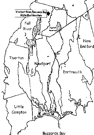
In 1985, Buzzards Bay and its watershed were designated by Congress as an 'Estuary of National Significance' under Section 320 of the federal Clean Water Act. While the Copicut Reservoir and woodlands are most often valued for preservation due to their importance as a public water supply source, the forest's role in supporting the quality and natural resource values of the greater Buzzards Bay ecosystem and particularly the Westport River subwatershed are only now being recognized.
continued...
CONTENTS
- Plan Summary
- Introduction
- Statement of Purpose
- Planning Process and Public Participation
- Community Setting
- Environmental Inventory and Analysis
- Inventory of Lands of Conservation & Recreation Interest
- Community Goals
- Analysis of Needs
- Goals and Objectives
- Action Plan
- Public Comments
- References
- Appendix
- Fall River Map